

We traveled to the Aoraki/Mount Cook area twice during our time in New Zealand. “Aoraki / Mount Cook is the highest mountain in New Zealand. Its height, as of 2014, is listed as 3,724 metres (12,218 feet). It is situated in the Southern Alps, the mountain range that runs the length of the South Island.” – Wikipedia
When we came through here the first time we stayed in the town of Lake Tekapo in the Mackenzie Basin.

Lake Tekapo is a small town of about 550 people, located at the southern end of a lake with the same name. We heard it called simply Tekapo, to avoid confusion with the lake itself. Lake Tekapo is the second largest lake in the area. We read that it is also the sunniest place in New Zealand, averaging around 200 hours more of sunshine than anywhere else in the country, according to Tekapo Tourism.

“In June 2012, an area of 430,000 hectares (1,100,000 acres) around Tekapo was declared the Aoraki Mackenzie International Dark Sky Reserve by the International Dark-Sky Association…as of 2024, this makes it the largest dark-sky reserve in the southern hemisphere. At the time of the designation in 2012, the reserve was the largest in the world.” – Wikipedia

“Selected for its very clear atmosphere, large number of clear sky nights, and relative freedom from light pollution, Mount John University Observatory is located on a small hill to the north of the town. Originally set up by the University of Pennsylvania (looking for a southern hemisphere location), it is now operated by the University of Canterbury.” – Wikipedia

The Observatory is a popular place to visit. You’ll pay a small fee for parking (credit only, no cash accepted) before driving up the one-lane road to the Observatory. Sheep will be grazing along the side of the road (because this is New Zealand) but they seem to mostly ignore the passing cars.


A cafe/coffee shop is open to the public at the Observatory’s main building, so you can grab a tea or coffee while you enjoy the views. Pro Tip – get here early! Space is very limited in the parking lot and the line can get long for coffee.


While Tekapo is a small town, it is a very popular stop for astronomers and people who are interested in sky-gazing. “The overnight population of Lake Tekapo can often double due to the number of visitors to the area. Lake Tekapo’s population increases during weekends due to the number of holiday homes in the village.” – Tekapo Tourism
In addition to a dark sky, Tekapo has some other interesting landmarks:
“The Church of the Good Shepherd is situated within the township on the shores of Lake Tekapo. It was built in 1935, and was the first church in the Mackenzie Basin.” – Wikipedia


“Close to the Church of the Good Shepherd is a well-known bronze statue of a New Zealand collie sheepdog. The statue was commissioned by Mackenzie Country residents in recognition of the indispensable role of the sheepdog in their livelihoods.” – Wikipedia


The footbridge used today, to walk to the Church of the Good Shepherd, was built to replace the Old Road Bridge, a suspension bridge which was stood from 1880-1954. The Old Road Bridge was originally built to replace a ferry, which wasn’t always able to operate due to frequent floods and strong northwest winds.
Once you cross the bridge it is a short walk get to both the Church of the Good Sheppard and Sheepdog statue.


We saw people fishing from the shore, and some kids playing in the water. You can swim here, though the water is fed from glacial runoff from the nearby Southern Alps – so, yeah, it’s a bit chilly. But it is also a beautiful light turquoise color because of the glacial runoff.


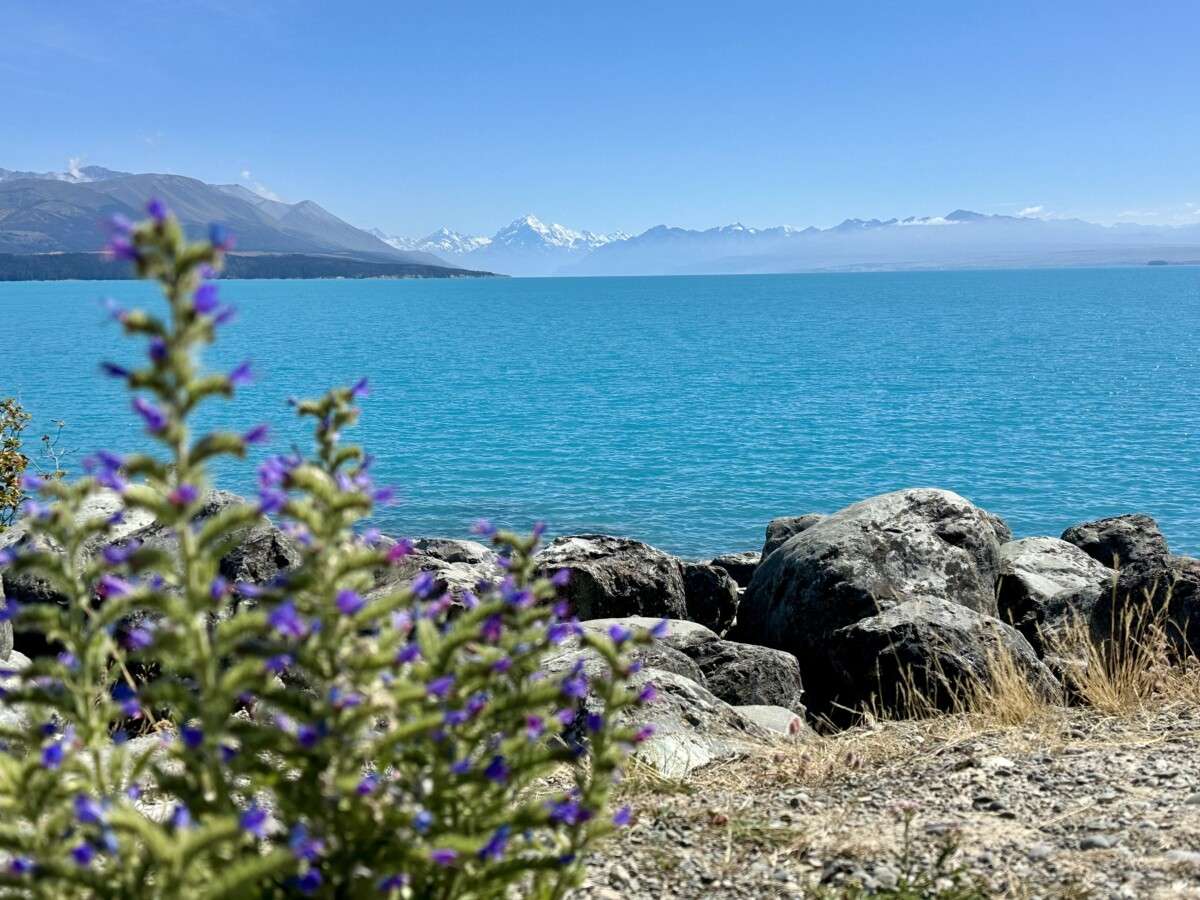
Lake Tekapo was an unexpectedly beautiful stop. The views, in every direction, are amazing. On our way out of town we passed nearby Lake Pukaki and had our first glimpse of Mt. Cook. It was even more amazing than the views at Lake Tekapo.

Stay tuned – In our next post we go on a popular hike at the base of Mt. Cook.

What a wonderful and peaceful place on earth that is…..Lake Tecapo…..absolutely depicts a pollution-free environment and atmosphere! I just wondered if there is data available regarding the health and life span of the people in Lake Tecapo Township… should be interesting 🤔!
Amazing photos. Lake Tekapo’s water is just such a brilliant blue! The photo of Mt. Cook and Lake Pukaki was absolutely beautiful. Such wonderful sights to view. Thank you for showing them to us. Happy you are home safely. June and Gene
Love the pics!!! ❤️❤️❤️. Welcome home.
Thank you Jerilyn for the post. This is one is on our list to visit. I appreciate the details and tips.
The pictures are absolutely amazing! It is wonderful to be traveling with you on your blog.
Thanks for taking us along on your amazing visit to Australia and New Zealand Great photos and interesting copy. Dad Jerry